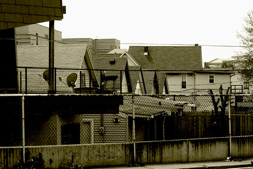
I was interested in the elevation difference between Virginia Avenue and the houses seen here. If you look to the top right, you can see the rooftop of the Lucas Oil Stadium.
4 comments:
Anonymous
said...
Very cool. Lots of little things to look at and those houses seem on top of each other.
Cool pic. That must be from the License Branch parking lot.
The elevation change is because of Pogue's Run, which is just a few tenths of a mile northwest (and now buried in a box culvert under the elevated RR trax by Anthem). This area is part of the "high ground" between Pogue's Run and Pleasant Run to the south.
I fear for those few houses, which are in the first block east of East St. south of the Villagio and directly across from Eli Lilly. Several new ones are (stalled) under construction, but there's a bunch of vacant lots.
At the left in your photo is a REALLY cool newer super-modern place just across the alley from the License Branch; there's another cool one at the opposite end of that block by East.
Thanks for the comments! This was taken from the BMV parking lot; one of the few fun things I've done at a BMV branch. I have noticed the stalled construction in the area; hopefully not for too much longer.

4 comments:
Very cool. Lots of little things to look at and those houses seem on top of each other.
I would have never known Merrill Street was that uphill till I ran 9 miles and running down (up?) Merrill was the last 200 feet. I was beat.
Cool pic. That must be from the License Branch parking lot.
The elevation change is because of Pogue's Run, which is just a few tenths of a mile northwest (and now buried in a box culvert under the elevated RR trax by Anthem).
This area is part of the "high ground" between Pogue's Run and Pleasant Run to the south.
I fear for those few houses, which are in the first block east of East St. south of the Villagio and directly across from Eli Lilly. Several new ones are (stalled) under construction, but there's a bunch of vacant lots.
At the left in your photo is a REALLY cool newer super-modern place just across the alley from the License Branch; there's another cool one at the opposite end of that block by East.
Thanks for the comments! This was taken from the BMV parking lot; one of the few fun things I've done at a BMV branch. I have noticed the stalled construction in the area; hopefully not for too much longer.
Post a Comment